GeoPDF Round-trip
In previous versions of Map2PDF for ArcGIS there was no way to view the GeoPDF back in ArcGIS. The latest release of this application allows you to do this! We are now able to bring in all the PDF map frames and layers then toggle them on and off just as you would a standard ArcGIS layer. Because it is treated as a standard ArcGIS layer, you can also export the content back out as a GeoPDF. Create GeoPDF --> work with GeoPDF in Reader --> View GeoPDF and annotations back in ArcGIS for further analysis. Sounds kinda like a round trip to me..

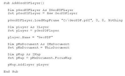
The following VBA code is for those hackers out there who already have Map2PDF for ArcGIS version 4.0 and would like to wrap their heads around the GeoPDF View COM Interface. Note that first the “Map2PDF for ArcGIS View” type library must be added to the project from the VBA editor's Tools->Reference command. This Interface will allow the developer to control view state, annotations, scale, etc...
 Cheers!
2 Comments:
Response?? GeoDataEmbed, an ESRI ArcMap Extension?? Game Changer?
http://www.directionsmag.com/article.php?article_id=2873&trv=1
http://globalmapsystems.com/
Thanks, Adam
9:23 AM EDT
Yeah...we definitely know about these guys! Actually, the owner is an ex TerraGo employee...
What they do is store the shapefile in the PDF document and they have a plugin that knows what to look for in the PDF space. Actually, you can store anything in a PDF file if you know what you are doing. Just yesterday I embedded a YouTube video in a PDF as a proof of concept.
They mentioned exporting data...We do that too and also have the ability to export markups as shp and KML.
They can identify features...so can GeoPDF but by adhering to the PDF standards rather than a one-off method.
Their "find" feature is more like ArcView 3.x which means that you can search by individual fields while ours is a free text search. We have found that the end PDF user appreciates the simple nature of the free text search. By the way, both products search on the EXACT SAME DATA.
They do attribute statistics...WTF is that? Why would a soldier on the ground who is using the PDF want to see stats on the data?
Their frequency table is nothing more than an HTML table that is produced on a simple query. We have nothing to compare to this but again, this might not be all that useful in the field.
They have a spatial join but I cannot figure out how to use it. Moreover, its a "point feature spatial join" so why would you want to join point features spatially?
At the end of the day, the PDF is an ISO standardized format. Adobe recognizes TerraGo for sticking to the standard. When the GeoPDF format is officially recognized by the OGC (near future), I think that we will being to see more and more companies producing PDF-based solutions like this one. In the mean time I encourage everyone to read this blog and, more importantly, to read between the lines for all the things to come. We have an outstanding raster product and later this year...a mobile app that I foresee being very beneficial to those guys out in the field collecting data.
I hope this helps explain our situation...
10:04 AM EDT
Post a Comment
<< Home