Inauguration Map
Check out the Inaguration Map for the upcoming election on the AcrobatUser.com Geospatial Gallery! Glenn beat me to the initial announcement yesterday but I thought I should expand upon what is in the map. This GeoPDF file was created using the TerraGo Composer Suite and there are a couple things that I think are pretty cool!
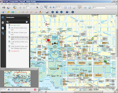 1. There are a few Bookmarks that help to identify the parade route. For a novice map user, Bookmarks are a key element for navigating through the material.
2. Each Bookmark takes the user to a specific location in the map.

 The data behind each push-pin for this example is a snap shot of that area. Note that the JPEG photos are stored in the PDF!
3. Finally, we have included a link to the Google Maps page with the Street View open for each section. I think the more elegant approach would have been to embed the Street View link directly in the PDF but this'll do...
 Thanks to all of you who worked on this...Good Job! Download the TerraGo Toolbar to measure and GPS track on the map.
Labels: GeoPDF, Inauguration Map
posted by Adam Estrada at 4:36 PM
![]()
![]()


0 Comments:
Post a Comment
<< Home