Collaborating in geospatial context since 2000!

Thursday, May 29, 2008

Embedding a 3D Google Map

I was reading through the Geospatial Blog Headlines where I discovered that Google finally released a browser plugin for Google Earth. So, I found a site that makes it extremely easy to embed a 3D map in your blog. Check out TakeitWithMe.com to produce the HTML needed to embed your map. See an excerpt from the GeoPDF Map Gallery below. Remember that you must first install the plugin from Google.


Note that this is extremely easy to do and after the small Google install, I was up and running in a matter of minutes.

Labels: , ,

Wednesday, May 21, 2008

Yahoo Pipes Blog Mashup

I finally figured this Yahoo Pipes thing out! Apparently, it's been out for a little more than a year now and I have yet to learn about all that it can do. So, after some brief exploration on this Yahoo website I put together a quick mashup of all the geospatial blogs I have found to be interesting over the years. The interface is easy to use and pretty quick to publish the RSS feeds I found on The Map Room website. I think for a future version of this application, I am going to create a mashup that also plots these RSS feeds out to a Yahoo Map. I am not exactly sure how to go about doing this but I think Pipes allows you to geocode the text from each feed. We'll see!!!


Tune back in later to see if I can ever get this to work as an actual mapping widget.

Labels: , ,

Tuesday, May 20, 2008

Geotagged Photos in GeoPDF

Way back in 2006, Patrick and crew developed a really cool pilot project for automatically adding geotagged photographs to a GeoPDF. The idea was to have someone in the field drive around and take photographs of any target area with a Ricoh Digital Camera. These cameras have a built in GPS which allows for automatic geotagging. You are also able to take it to the next level by using the camera to record an audio clip. Pretty cool indeed!!! Here is the workflow:

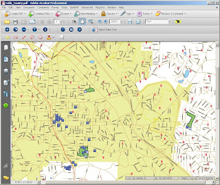
1. Create a base map to work with. This can be anything from a high resolution image to a simple vector layer that is exported to GeoPDF.

2. Select the directory full of geotagged images. Note that future releases of this application will allow the user to ingest geotagged images from Google Maps and Flickr.

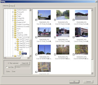
3. Select all the photos you would like to add then click the OK button. This will load all your photos in to the GeoPDF and maintain the spatial integrity of the data.


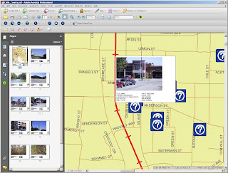
4. You will now see that each photo is adding to both the map space as well as a separate page in the table of contents. You can browse to each image by selecting it in the map or by clicking on it in the table of contents.

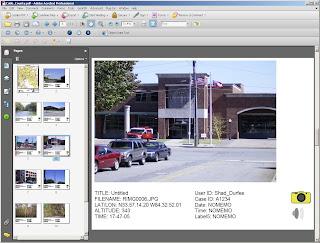
5. To hear the audio clip, select the speaker icon and to return to the map and select the camera icon. It's that easy!

To download this data set click here...

Labels: , , ,

Thursday, May 15, 2008

Google and ESRI Geocollaborate

News from Where 2.0:

This week in California, Google and ESRI announced that they will be working towards tighter integration with each other. In about 4 weeks, ESRI is planning to release an extension to their already rich GIS functionality. This extension will provide more KML support for use in Google Apps like Google Maps and Google Earth. What does this mean to "neogeographers" like us? We all need to brush up on our KML...I suggest KML for Dummies!!!

The following recording from Where 2.0 is the interaction between Jack Dangermond (ESRI) and John Hanke (Google).


For more information on this topic click here...

Monday, May 12, 2008

Where 2.0 Conference

Where 2.0 starts today in Burlingame, CA and our very own George Demmy is on site to check things out. This conference is geared towards those of you who use a wide variety of tools to resolve your location-related requirements. Typical attendees are CIO's, open source developers, researchers and acadimics, what they are calling neo-geographers, and many more...Check out the conference website in the link below!


Where 2.0 Conference 2008

Wednesday, May 07, 2008

Map2PDF for Raster

The raster team at TerraGo has been hard at work at getting requirements in place for the next generation of Map2PDF for Raster. An example dataset has been put together to demonstrate how anyone can export a wide variety of raster data to GeoPDF. Follow the links below to see the PDF's that were created from Landsat TM data. You might also want to check out a more in-depth description of what the various Landsat TM band combinations are and why they might be useful.

Download these files and play around with them as you see fit. Note that you will have to download the free GeoPDF toolbar from the TerraGo website. Its always better to download these files to your desk top too...click on the links below to download each GeoPDF.

  • 3,2,1 Band Combination: The "natural color" band combination.
  • 4,5,3 Band Combination: This combination of near-IR (Band 4), mid-IR (Band 5) and red (Band 3) offers added definition of land-water boundaries and highlights subtle details not readily apparent in the visible bands alone.
  • 7,4,2 Band Combination: This combination provides a "natural-like" rendition, while also penetrating atmospheric particles and smoke.
  • 4,5,1 Band Combination: Healthy vegetation appears in shades of reds, browns, oranges and yellows. Soils may be in greens and browns, urban features are white, cyan and gray, bright blue areas represent recently clearcut areas and reddish areas show new vegetation growth, probably sparse grasslands.
  • 4,3,2 Band Combination: The standard "false color" composite. Vegetation appears in shades of red, urban areas are cyan blue, and soils vary from dark to light browns.
  • All Bands: This one is really cool because you can interactively turn all the bands on and off.

What's next? Hyperspectral to GeoPDF?

Thursday, May 01, 2008

Fun with Hyperlinked data

GeoPDFs are cool and do so much more than a static map can. There is a lot of geospatial data out there and with that comes a vast array of interesting ways to store and disseminate the data therein. GeoPDF allows you to maintain all spatial integrity but at the same time Index and Hyperlink to other GeoPDFs. Please click the link below to see this in action. If you don't already have the GeoPDF toolbar, you must have it installed in order to view everything correctly. Thanks to John Mueller for creating this dataset!!!


--> Click Here <--


Use your curser and hover over the graphic until the Back and Next icons appear. Use them to toggle back and forth between graphics. Try it out and you'll see what I mean.