Collaborating in geospatial context since 2000!

Friday, December 12, 2008

Landsat Archive to GeoPDF?

Jesse mentioned again that the entire Landsat data archive is now available to download FOR FREE! This really opens a lot of doors to those of you who require this moderate resolution data type that has been so successful all over the world for the past 35+ years.  

But, what if you don't have a buly image processing application like IMAGINE, PCI, or ENVI and still need to work with these data on your desktop?  The PDF file format certainly bridges that gap!  

Adobe has published that there are something like 750,000,000+ desktops with the free Adobe Reader on them!  That is more desktops than there are Windows operating systems, right?  If not more, it's certainly close!  Anyway, I noted in previous posts that we now have the ability to create a single GeoPDF file that contains all or selected image bands from the source file.  Imagine having everything you need from the input data source stored in a single document.  With the inherent compression of the PDF format I have been able to get a 140meg file down to less than 10 megs!  Moreover, imagine a single file that contains Landsat imagery from several different dates!  What about a single PDF file that has a Landsat scene with all 7 bands as one layer, a Leica ADS80 image from the same spatial extent as another layer and then one of the free USGS topographic maps ALL IN THE SAME PDF!  Wow!  Several image sources stored in a single file that can be sent through fire walls and network filters as a single document is already of great benefit to folks all over the world!  Coupled with the free GeoPDF toolbar, the analysis that can be done on image data in a single document is tremendous... 

Landsat 7 courtesy of NASA

I hope those of you out there who are using Landsat data can see the true value of working with remotely sensed data in the GeoPDF format...

Labels: , ,

Thursday, November 20, 2008

LandSat 7 GeoRSS Feed

October 1st 2008 marked the day when the entire LandSat ETM+ data archive was released to the general public completely free of charge.  They have also started publishing the latest editions to their archive via GeoRSS.  What better way to visualize this feed than in a map!  I put together a Yahoo Pipe that processes this feed and plots it out in a Yahoo Map.  It took approximately 2 minutes to create and publish this pipe, however the Blogger style sheet is doing funny things with the Pipes Badge! Try clicking on the link below to see the full feed directly in Yahoo Pipes.


Interested in viewing LandSat 7 data in the GeoPDF format?  Click here for a previous post. As always, gain access to the GeoSpatial content in the PDF file by downloading the free TerraGo Toolbar.

Labels: ,

Tuesday, August 19, 2008

More on Multispectral GeoPDFs

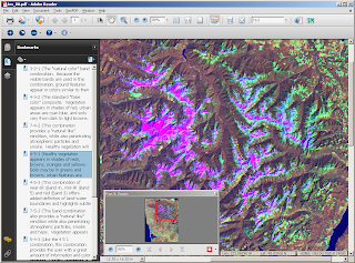
For more than 3 decades the Landsat program has been collecting data all over the globe. Uses for these data are vast and can include support for modeling of carbon fluxes to the atmosphere, marine protection, and of course terrestrial disaster relief. Check out the application matrix for this sensor...These data can be downloaded very inexpensively and processed in a variety of different ways. Why not export all bands as a completely dynamic GeoPDF? I used the pre-alpha release for Map2PDF for Raster to export all 7 bands from a Landsat scene and then set up the document to display 10 different band combinations on the fly. Let me demonstrate how I did this.

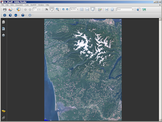
1. I first created the GeoPDF by choosing all the available bands from the input data set. My default display mode is "true color" or band combination 3, 2, 1. This was a 127 meg TIFF file that was exported to a 25 meg GeoPDF! I was actually able to get it down to less than 5 megs but of course there is resolution loss when doing this...


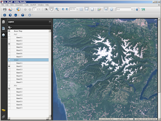
2. Open the Layers tab on the left-hand side of your Acrobat Reader and note how the layers are being handled. We can now adjust the band combinations by assigning a single image band to display as red, green or blue in the PDF space. Each group is treated as a radio button and will allow you to only choose one at a time!


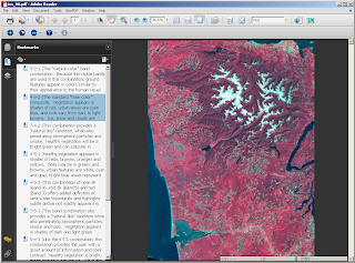
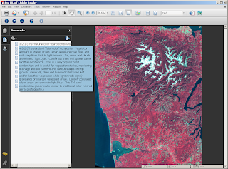
3. Bookmarks are generally considered to be a way to define an action like zooming to a particular location on a certain page in your PDF. That is absolutely true BUT you can also use them to maintain view state, run a script, etc... I used bookmarks to "define" 10 different band combinations in a single PDF. This is the equivalent of viewing 10 different images or changing the view state in an expensive Desktop Remote Sensing application. Note that I was able to add a pretty long description for each band combination to help explain what is actually being displayed. Very cool...


4. Finally, we can utilize all the options on the TerraGo Toolbar in addition to what Adobe has to offer with their core functionality. I find the Pan & Zoom window especially useful as it provides a quick overview of your image.


When I finished working on my GeoPDF, I published it to my free Acrobat.com account so that other folks can use my file. I find that this is the easiest way to disseminate files that are larger than 5 megs. On Acrobat.com, download the file to gain access to everything mentioned above. This website in our geospatial domain is only good for previewing the data not for making use of everything that the GeoPDF has to offer. I also strongly recommend downloading Acrobat Reader 9.0 because of its beefed up rendering speeds and advanced analysis tools.

Map2PDF for Raster is not limited to any one particular sensor type or even input format type...This example is simply another way to get Landsat data to the general public. Enjoy!

Labels: , ,