Collaborating in geospatial context since 2000!

Tuesday, August 19, 2008

More on Multispectral GeoPDFs

For more than 3 decades the Landsat program has been collecting data all over the globe. Uses for these data are vast and can include support for modeling of carbon fluxes to the atmosphere, marine protection, and of course terrestrial disaster relief. Check out the application matrix for this sensor...These data can be downloaded very inexpensively and processed in a variety of different ways. Why not export all bands as a completely dynamic GeoPDF? I used the pre-alpha release for Map2PDF for Raster to export all 7 bands from a Landsat scene and then set up the document to display 10 different band combinations on the fly. Let me demonstrate how I did this.

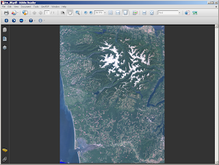
1. I first created the GeoPDF by choosing all the available bands from the input data set. My default display mode is "true color" or band combination 3, 2, 1. This was a 127 meg TIFF file that was exported to a 25 meg GeoPDF! I was actually able to get it down to less than 5 megs but of course there is resolution loss when doing this...

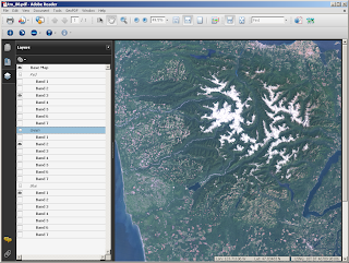
2. Open the Layers tab on the left-hand side of your Acrobat Reader and note how the layers are being handled. We can now adjust the band combinations by assigning a single image band to display as red, green or blue in the PDF space. Each group is treated as a radio button and will allow you to only choose one at a time!

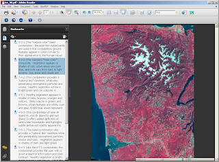
3. Bookmarks are generally considered to be a way to define an action like zooming to a particular location on a certain page in your PDF. That is absolutely true BUT you can also use them to maintain view state, run a script, etc... I used bookmarks to "define" 10 different band combinations in a single PDF. This is the equivalent of viewing 10 different images or changing the view state in an expensive Desktop Remote Sensing application. Note that I was able to add a pretty long description for each band combination to help explain what is actually being displayed. Very cool...
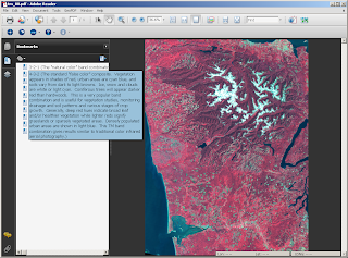

4. Finally, we can utilize all the options on the TerraGo Toolbar in addition to what Adobe has to offer with their core functionality. I find the Pan & Zoom window especially useful as it provides a quick overview of your image.
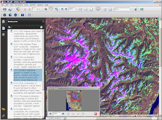

When I finished working on my GeoPDF, I published it to my free Acrobat.com account so that other folks can use my file. I find that this is the easiest way to disseminate files that are larger than 5 megs. On Acrobat.com, download the file to gain access to everything mentioned above. This website in our geospatial domain is only good for previewing the data not for making use of everything that the GeoPDF has to offer. I also strongly recommend downloading Acrobat Reader 9.0 because of its beefed up rendering speeds and advanced analysis tools.

Map2PDF for Raster is not limited to any one particular sensor type or even input format type...This example is simply another way to get Landsat data to the general public. Enjoy!

Labels: , ,

Wednesday, July 23, 2008

Multi-band Raster GeoPDFs

Over the past few months, the raster team has been working hard to iron out the plans for the next generation of Map2PDF for Raster. There have been many interesting developments that have come out of it like adding the ability to query for and display more than just 3 bands of base data at a time. I posted an article about creating a GeoPDF out of AVIRIS data with 224 bands and got mixed reviews as to why this would be useful. The problem was with the way we used Adobe's blend modes when interactively turning visual bands on and off in Adobe Reader. There are quite a few blend modes to choose from and most of them are not applicable to the world of GIS and Remote Sensing! It's ok though as we have found a couple methods that work and are actually pretty useful.
  1. Difference: Subtracts the darker of the two constituent colors from the lighter color (which is the background for the PDF).
  2. Exclusion: Produces an effect similar to that of Difference mode but lower in contrast.
In previous examples, I used blend modes that completely covered the base map data with other bands of sensor data. The Hyperspectral example was ultimately botched because of this. Well...that and we were not stretching the histogram for each band added after the RGB base map.

The graphic that you see below represents a very small QuickBird scene with an IR band that is displayed as Band 4 in the Layers Tab. Open the PDF and click on the Layers Tab to see how blending modes are implemented in the PDF space. This PDF was created with low image quality to save space!


Download the GeoPDF Toolbar to gain access to all the spatial information!


Enjoy!

Labels: , ,

Thursday, July 17, 2008

ERDAS Image Web Server

Do you own large amounts of raster data? The ERDAS Image Web Server is a COTS solution that easily allows your organization to quickly integrate raster data in to your GIS. ESRI has a similar solution in the ArcGIS Image Server but wouldn't it be more adventageous to manage your raster data through a product whos main focus is the speedy delivery of large volumes of raster data? There are pros and cons to both products I'm sure...for example, both applications provide a way to extend the core functionality. ESRI gives you an API (more than likely through ArcObject programming) while ERDAS gives you the Image Integration Framework. I would be really interested to see a side by side comparison for both!!! NOTE: Leica (now ERDAS) acquired ERMapper last year.

vs.

Labels: , , ,

Monday, June 23, 2008

Hyperspectral GeoPDF

Hyperspectral Imagery has been an interest of mine for some time now and I think I've found a pretty good way to display it in a map. I used Map2PDF for Raster and quickly added the first 54 bands (out of 224). I assigned each band an arbitrary color of my choosing for this example but a more qualified Remote Sensing Scientist could assign any color they want to as many bands as they want. There is NO LIMIT on the amount of bands a user can display. This image is NOT geo-referenced so please don't look for any spatial information in there but I would encourage you to download the data from here or from the Menu option in this flash viewer.


Again, this is AVIRIS data that I quickly converted to GeoPDF and uploaded to Acrobat.com so that anyone can download and view it. When you do download the entire file, open the Layers tab to gain access to all 54 bands. I think a qualified eye will be able to see the possibilities with this one! Enjoy...

Labels: , , ,

Friday, June 20, 2008

Why GeoPDF?

The question "Why GeoPDF?" has come up a lot lately primarily because Adobe released their GeoSpatial PDF format. I would like to share what I know about this format and possibly clear the air about the question at hand...


What is GeoPDF? GeoPDF is a geospatial extension to the Adobe PDF file format, from TerraGo Technologies. It is used to present GIS and mapping data in a standard Adobe Systems PDF. This extension adds a coordinate transformation matrix and other metadata to allow transformation of PDF coordinates to a projected Cartesian coordinate system. GeoPDFs often include other advanced PDF features such as layers and object data which can add significant GIS functionality to the file, particularly when used with the TerraGo Technologies plugin to Adobe Reader.

GeoPDF is still a PDF which means that ANYONE with Adobe Acrobat Reader can view your map data (look in the link to see that whoever added the Adobe Acrobat definition in Wikipedia, chose to display a graphic of a map!). It's true that you must download the GeoPDF Toolbar to gain access to the GIS functionality but wouldn't you expect to do this in most applications to access the intended functionality? I often write about Google Earth, Photosynth, and a variety of other GIS/Visualization Tools all of which require a download of some kind! A key benefit of the GeoPDF Toolbar is that you get GPS Tracking functionality.


What information can I include in my GeoPDF? There is quite a bit of data that can be added! For example, let's say that I am using Map2PDF for ArcGIS and in my map layout I have a raster image as a background, a shapefile for my streets data, an ArcSDE layer for parcel data and finally I create custom symbology and labels for each layer. I can export each one of these features to GeoPDF (with hyperlinks and annotations) in a separate layer in the final map. How is attribute data maintained? The GeoPDF export creates the equivalent for attribute data which is called Object Data. By creating object data in your output map, which is optional by the way, you can search for all the attribute data just as if it were in its original form in ArcGIS. With the ability to Zoom To a selected feature, you have a pretty powerful geo-search tool.

Map2PDF for Acrobat add-ons included GeoMark tools that allow users to add shapes and standard or custom stamps with comments. MapAssembler lets users combine maps and grids to create Map Books. Map2PDF for Acrobat lets users turn any PDF-based map into a georegistered map - a GeoPDF file - simply by entering two coordinates. But, there's much more to Map2PDF for Acrobat than that.

Map Book, Map Book, Map Book!!! What the heck is a Map Book? A Map Book is a a set of GeoPDFs that are indexed together to create a seamless interaction between the end user and the data. Check out the Map Book that I posted earlier this year! I called it Fun with Hyperlinked Data. I did go a little overboard with the Lightbox2 javascript but it does a great job in helping to tell the story! In a Map Book series, there is also the ability to search for features stored in an external database and create custom functionality through GeoJavascript.

Map2PDF for Raster: I have seen 6 gigabytes of raster data compressed down to a 400 megabyte GeoPDF. Wow! That is an impressive compression ratio! I mentioned earlier that we can create layered PDFs which means that with our raster data, we can see a base layer as an RGB image but then we can add additional bands to be turned on and off as needed. For Landsat ETM+ data we can create a base map with bands 1, 2 and 3 then add additional bands and assign a particular color to each one. Because they are treated as seperate layers, you have the ability to turn them on and off dynamically. Imagine what you can do with low-resolution multispectral data like AVHRR? MODIS/ASTER? Click here to download some example data.

Things to look forward to: Mobile apps, Enhanced GeoJavascript, Advanced GPS Track Manager, leveraging Acrobat 9.0 functionality like Adobe AIR and much more...


Labels: , , , , ,

Friday, June 06, 2008

GeoPDF.com Announcement

This has been a big week for TerraGo Technologies! ESRI announced that they are supporting Adobe's spatially registered PDF format, several GeoPDF beta programs were released and TerraGo has finally lauched GeoPDF.com!


The initial release of this website is meant for our beta testers to chat about beta testing GeoPDF's and also allow them to upload their own GeoPDFs to the gallery. A formal announcement will be released when the website if officially launched.

The available beta programs are GeoPDF Mobile, Map2PDF for Raster, AutoCAD Map 3D, and Map2PDF for ArcGIS. TerraGo is also beefing up the licensing mechanism so look forward to concurrent licensing in all products to come!!! Enjoy and have a great weekend...

Labels: , , ,